Photoscenery: Porovnání verzí
| (Nejsou zobrazeny 2 mezilehlé verze od stejného uživatele.) | |||
| Řádka 9: | Řádka 9: | ||
*ZL16, ZL17, ZL18: Various squares | *ZL16, ZL17, ZL18: Various squares | ||
| + | Resolutions: | ||
* ZL16 = the most commonly used resolution. It is sufficient resolution for common flying, however, closer look during flight at low altitude or during landing reveal the worse resolution of the texture. On te other hand, it does not consume too much space on disc and it does not have significant effect on loading of the simulator. One [[Square]] occupies approximately 2-2.5 GB on disc. | * ZL16 = the most commonly used resolution. It is sufficient resolution for common flying, however, closer look during flight at low altitude or during landing reveal the worse resolution of the texture. On te other hand, it does not consume too much space on disc and it does not have significant effect on loading of the simulator. One [[Square]] occupies approximately 2-2.5 GB on disc. | ||
| Řádka 101: | Řádka 102: | ||
| − | === | + | ===ZL16: photosceneries of various parts of the world=== |
* http://zonephoto.x-plane.fr/Cartes.php | * http://zonephoto.x-plane.fr/Cartes.php | ||
Aktuální verze z 1. 3. 2016, 08:48
Obsah
Introduction
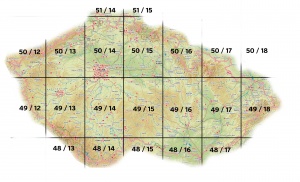
Photoscenery is texture placed on the surface of the landscape. It can be obtained e.g. from Google Earth. Photoscenery replace (overlay) the default X-plane textures and it displays the real look of the landscape from an aerial view. Photosceneries are available in different resolutions (which are called Zoom Levels, ZL) and they are packaged separately as individual squares.
Following photosceneries are available for the Czech Republic and Slovakia:
- ZL16: Complete photoscenery for the Czech Republic and Slovakia
- ZL17: Almost complete photoscenery for the Czech Republic and Slovakia
- ZL16, ZL17, ZL18: Various squares
Resolutions:
- ZL16 = the most commonly used resolution. It is sufficient resolution for common flying, however, closer look during flight at low altitude or during landing reveal the worse resolution of the texture. On te other hand, it does not consume too much space on disc and it does not have significant effect on loading of the simulator. One Square occupies approximately 2-2.5 GB on disc.
- ZL17 = the second most common resolution. It has better resolution but at the cost of significant growth of data volume (4-times more).
The Square with photoscenery always includes some 3D terrain (Mesh) and definition of water areas. However, it depends on the author of the photoscenery which type of Mesh and water areas was included in particular photoscenery. If quality of Mesh and water areas (which came with the photoscenery) is not sufficient (e.g. Mesh has poor resolution or water ares are not defined at all - this is case of following photosceneries) they can be upgraded by replacing the .dsf file in the photoscenery with another one from external source (see the description at the bottom of the page).
Sources of photosceneries
Photosceneries in ZL16 and ZL17 and in some case also in ZL18 are available for Czech Republic and Slovakia.
ZL16: Complete photoscenery for the Czech Republic and Slovakia
- Czech Republic
- http://www.uloz.to/20266202/z-cz-48-13-terrain-rar
- http://www.uloz.to/20266546/z-cz-48-14-terrain-rar
- http://www.uloz.to/20266314/z-cz-48-15-terrain-rar
- http://www.uloz.to/20266470/z-cz-48-16-terrain-rar
- http://www.uloz.to/20266522/z-cz-48-17-terrain-rar
- http://www.uloz.to/20285590/z-cz-49-12-terrain-rar
- http://www.uloz.to/20285614/z-cz-49-13-terrain-rar
- http://www.uloz.to/20285608/z-cz-49-14-terrain-rar
- http://www.uloz.to/20285592/z-cz-49-15-terrain-rar
- http://www.uloz.to/20285598/z-cz-49-16-terrain-rar
- http://www.uloz.to/20285596/z-cz-49-17-terrain-rar
- http://www.uloz.to/20285594/z-cz-49-18-terrain-rar
- http://www.uloz.to/20289928/z-cz-50-12-terrain-rar
- http://www.uloz.to/20290508/z-cz-50-13-terrain-rar
- http://www.uloz.to/20291030/z-cz-50-14-terrain-rar
- http://www.uloz.to/20291558/z-cz-50-15-terrain-rar
- http://www.uloz.to/20292452/z-cz-50-16-terrain-rar
- http://www.uloz.to/20292920/z-cz-50-17-terrain-rar
- Slovakia
- http://www.uloz.to/xBS2WF7/slovakia-ortho-xpl10-part01-rar
- http://www.uloz.to/xH37X4S/slovakia-ortho-xpl10-part02-rar
- http://www.uloz.to/xUWzbe2/slovakia-ortho-xpl10-part03-rar
- http://www.uloz.to/xJcg5aP/slovakia-ortho-xpl10-part04-rar
- http://www.uloz.to/xRt7X4S/slovakia-ortho-xpl10-part05-rar
- http://www.uloz.to/xhyt6Nb/slovakia-ortho-xpl10-part06-rar
- http://www.uloz.to/xQYELWv/slovakia-ortho-xpl10-part07-rar
- http://www.uloz.to/xGaeFj4/slovakia-ortho-xpl10-part08-rar
- http://www.uloz.to/xE6NbYs/slovakia-ortho-xpl10-part09-rar
- http://www.uloz.to/xy5vVbf/slovakia-ortho-xpl10-part10-rar
- http://www.uloz.to/x2idjKh/slovakia-ortho-xpl10-part11-rar
- http://www.uloz.to/xHCj5aP/slovakia-ortho-xpl10-part12-rar
- http://www.uloz.to/xk3MLWv/slovakia-ortho-xpl10-part13-rar
- http://www.uloz.to/xcqFeKd/slovakia-ortho-xpl10-part14-rar
- http://www.uloz.to/xHrBRhg/slovakia-ortho-xpl10-part15-rar
- http://www.uloz.to/xxyDdg8/slovakia-ortho-xpl10-part16-rar
- http://www.uloz.to/x87moHE/slovakia-ortho-xpl10-part17-rar
- http://www.uloz.to/xsAH3rW/slovakia-ortho-xpl10-part18-rar
- http://www.uloz.to/xuhMkhg/slovakia-ortho-xpl10-part19-rar
- http://www.uloz.to/xWiFX4S/slovakia-ortho-xpl10-part20-rar
- http://www.uloz.to/xP3UVXz/slovakia-ortho-xpl10-part21-rar
- http://www.uloz.to/xy1hFj4/slovakia-ortho-xpl10-part22-rar
- http://www.uloz.to/xbCN1gt/slovakia-ortho-xpl10-part23-rar
- http://www.uloz.to/xutj5aP/slovakia-ortho-xpl10-part24-rar
- http://www.uloz.to/x6fScjX/slovakia-ortho-xpl10-part25-rar
- http://www.uloz.to/xUgsbe2/slovakia-ortho-xpl10-part26-rar
- http://www.uloz.to/xamvoMA/slovakia-ortho-xpl10-part27-rar
- http://www.uloz.to/x9Qg3rW/slovakia-ortho-xpl10-part28-rar
- http://www.uloz.to/xwMpxuG/slovakia-ortho-xpl10-part29-rar
- http://www.uloz.to/xVvWVbf/slovakia-ortho-xpl10-part30-rar
ZL17: Almost complete photoscenery for the Czech Republic and Slovakia
- http://www.uloz.to/xsJHt7g/zPhotoXP_%2B50%2B017_17_Nysa_XP10_2013-01.7z
- http://www.uloz.to/xbMior4/zPhotoXP_%2B50%2B016_17_Nachod_XP10_2013-01.7z
- http://www.uloz.to/xetzumS/zPhotoXP_%2B50%2B015_17_HradecKralove_XP10_2013-01.7z
- http://www.uloz.to/xKotKq1/zPhotoXP_%2B50%2B014_17_Praha_XP10_2013-01.7z
- http://www.uloz.to/xaEMpXk/zPhotoXP_%2B50%2B013_17_Chemnitz_XP10_2013-01.7z
- http://www.uloz.to/xWz8jKJ/zPhotoXP_%2B50%2B012_17_Zwickau_XP10_2013-01.7z
- http://www.uloz.to/x1UkKq1/zPhotoXP_%2B49%2B018_17_Zilina_XP10_2013-01.7z
- http://www.uloz.to/x3VrXgT/zPhotoXP_%2B49%2B017_17_Olomouc_XP10_2013-01.7z
- http://www.uloz.to/xVordmf/zPhotoXP_%2B49%2B016_17_Brno_XP10_2013-01.7z
- http://www.uloz.to/xYDuYuX/zPhotoXP_%2B49%2B015_17_Jihlava_XP10_2013-01.7z
- http://www.uloz.to/xkivEZA/zPhotoXP_%2B49%2B014_17_Tabor_XP10_2013-01.7z
- http://www.uloz.to/x7Z11mf/zPhotoXP_%2B49%2B013_17_Pilsen_XP10_2013-01.7z
- http://www.uloz.to/xKyN3ME/zPhotoXP_%2B49%2B012_17_Weiden_XP10_2013-01.7z
- http://www.uloz.to/xW7fYC2/zPhotoXP_%2B48%2B017_17_Bratislava_XP10_2013-02.7z
- http://www.uloz.to/xBB3kuX/zPhotoXP_%2B48%2B015_17_Horn_XP10_2013-02.7z
- http://www.uloz.to/x3uMBgT/zPhotoXP_%2B48%2B014_17_Traun_XP10_2013-01.7z
- http://www.uloz.to/xiKYQC2/zPhotoXP_%2B48%2B013_17_Passau_XP10_2013-02.7z
- http://www.uloz.to/xzpPpmf/zphotoxp-51-014-17-cottbus-xp10-2013-02-7z
ZL16: photosceneries of various parts of the world
Mesh
3D terrain (Mesh) and definitions of water ares are included in the photoscenery. If quality of Mesh and water areas (which came with the photoscenery) is not sufficient (e.g. Mesh has poor resolution or water ares are not defined at all) they can be upgraded by replacing the .dsf file in the photoscenery with another ones, e.g. from following sources.
